

Day 7 - Segments 15-17, Sargent's Mesa
The Colorado Trail is generally high up, above 3000m, and any towns near the trail are at much lower elevation. That means detours to town require a long and somtimes arduous climb back up. Leadville and Buena Vista, both mandatory detours for bicyclists because the Colorado Trail goes into designated wilderness areas, are exceptions in that respect, at least going south/west. There are several ways from Salida to return to the trail, one of the better one might be going directly to Marshall Pass as this avoids heavy car traffic, although the dirt road climb will not be empty. A few years ago, I did Marshall Pass to Salida the opposite way on the Great Divide Mountain Bike route. However, going straight to Marshall Pass would also skip a big chunk of the Colorado Trail and that is not what I wanted to do. Unfortunately, the direct way back to the trail is Highway 50, a nasty road uphill with lots of traffic and no shoulder. It is 1800 feet, 15 miles, 1 1/2 hours from Salida, although the first half hour and 7 miles to Poncha Springs are flat and have a wide shoulder. So from Poncha Springs, about 1400 feet climbing, 1 hour, on an unpleasant road, not really that terrible. There is a commercial bike shuttle operating out of a gas station from Poncha Springs that makes several runs in the morning to Monarch Pass and probably could take you other places (although there may be some minimum number of rider requirements if it isn't part of their route).
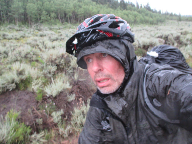
It was a cool morning and clouds were coming in. Initially, it was dry, but in the afternoon, probably around Marshall Pass, I got the first hail of the trip. Gentle hail, as bizarre as this sounds. A few miles ahead of me, the trail was pounded very hard as I later heard from a through-hiker and I could still see that because there was snow/hail on the ground around Sargent's Mesa.
It was a cool morning and clouds were coming in. Initially, it was dry, but in the afternoon, probably around Marshall Pass, I got the first hail of the trip. Gentle hail, as bizarre as this sounds. A few miles ahead of me, the trail was pounded very hard as I later heard from a through-hiker and I could still see that because there was snow/hail on the ground around Sargent's Mesa.
After Marshall Pass, we get into cowpoop area for a while. While the Sargent's mesa segment has a terrible reputation, it isn't that awful. For sure, it isn't great riding or scenery, but on dry days may be decent. However, it was a wet day and the trail was muddy, too muddy for riding, although fortunately not yet too muddy for pushing (on other routes, mud can get so sticky that wheels won't turn and than carrying the bike or waiting things out is the only option). As I started to climb up Sargents, Mike Kunneke was coming down. Mike was the oldest starter in the Colorado Trail Race at 64 and rode a single speed bicycle. By then, half the starters had already quit and the fast guys had finished, but he persevered and became the last finisher of the event (which puts him into the top half among starters). By then, he had already some spills in the mud, whereas I had mine still ahead (I didn't know that yet, of course, and it was only one slide in the mud).
 |
| Mike Kunneke, on single speed - he finished the full route |
At the top, my rear brake gave out. It was cold and the ground was covered with snow/hail. Evidence of heavy weather that had come through ahead of me, but never quite hit me. I made some hot chocolate and got going on the repair task. Initially, I hoped a change of brake pads would do, but that didn't make a difference. Instead, it was the hydraulics and I refilled and bled with chain lube. Did the job, I had no more problems with the rear brake for the rest of the trip. Shimano brakes use mineral oil, so there is no nasty brake fluid to deal with, although I still think cable disc brakes like BB7 would be better for those trips. Earlier this year, I had torn off a hydraulic hose and then was lucky that I could fix it on the trail, not a given that trailside repairs are feasible with such brakes.
The temperatures became more pleasant again as the evening progressed and the storm moved out. I rode for a few hours after sunset and then made camp at Baldy Lake. Nice campsite, although added a bonus mile and extra climbing the next morning.
 |
| Baldy Lake a little offroute in segment 17 |
Day 8 - Segment 17, 18, and La Garity Wilderness Detour
 |
| Tree eating the trail marker |
The ride continued through cattle country with bad water. Until then, I really liked the fact that water on the Colorado Trail was so easily available and of good quality (compared to any of the routes in California). The scenery has a different feel to the previous more forested ridges. But segments 16-18 are not among the highlights of the Colorado Trail. Segment 17 also seems to have lots of gratuitous climbs. By the end of segment 18, cyclists are forced onto a dirt road detour around the La Garita Wilderness, which increases speed, but is not very attractive.
By the time I got on to the dirt road, it was afternoon and the weather started to deteriorate, eventually becoming the worst day of my trip as far as the weather was concerned. I was not alone: over the next days, I met a number of people, motorcyclists, through-hikers, other bicyclist, that got caught in this weather at many different places. It was odd to have continuous rain for that long and regional (not just local).
I was not a happy rider that evening:
By about 10 pm (still raining), I pulled into a day use area (there would have been more official campgrounds ahead, but this worked fine for me) and quickly went into my tent to warm up and dry as far as possible. I had done the first big climb of the detour, the next morning would only be another 2 hours or so to get to the top of Slumgullion Pass.
Day 9 - detour to Lake City
The rain stopped in the morning, but the weather remained unstable. I dried things a little bit in the morning sun and then continued.
By the time I got to the top of Slumgullion Pass, it started to rain a little bit, but more disconcerting were ominous clouds. The next two sections would largely be above tree line and include the highest point in the Colorado Trail, so this was looking iffy. I puttered around a bit at the top of the Pass: Should I turn left and continue? Or drop into the valley to Lake City (which would cost me yet another day)? Eventually, thunder decided in favor of the Lake City descent, a very rapid road ride dropping 3000 feet.
Lake City is a cute little mountain town, not much going on, although it milks the fact that this is where Alferd Packer killed and ate his companions while traveling there during the winter in 1874. Aside from the ghosts of his companions, the trackleaders website also showed the ghosts (faded blue) of wanna-be CT racers that didn't make it very far (there are even more of them in Silverton).

Once in town, you can choose between the Cannibal Grill or the Packer Saloon.
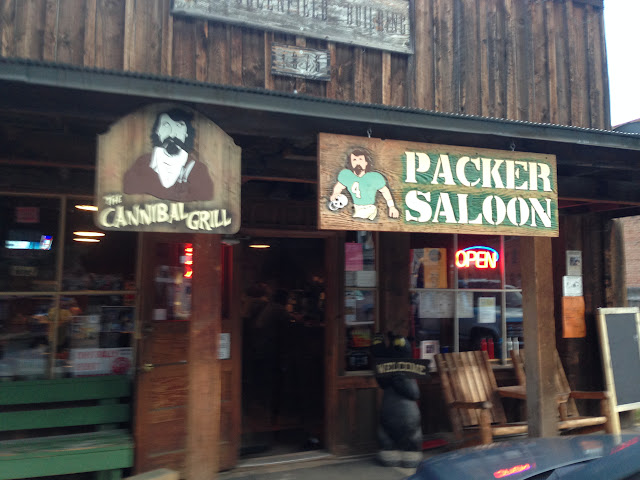
Lots of motorcycles, ATVs, and art galleries in the town, an incongruous juxtaposition. Two small grocery stores. I had dinner at the Cannibal Grill and dried out in the Matterhorn motel. It was a very good decision because only that day would have thunderstorms, then the forecast was for 3 days of stable weather.

Day 10: Returning to the route and Segments 22 and 23
The punishment for a comfortable evening in Lake City was the hard 3000 foot road climb back to Slumgullion Pass. Not too much traffic and cars gave me room, but the altitude gain made for a hard morning. Then down on the other side of the Slumgullion Pass and a small climb to Spring Creek Pass, so I already had a hard workout before the day on the trail really started. I arrived at Spring Creek Pass, the start of Segment 22, a bit after 11 am. Not having to worry about lightning storms on those two sections was good and worth the additional day that the Lake City detour added to let the weather settle again.
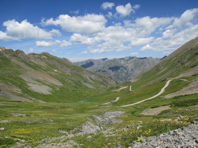
While those two segments are very attractive, Jarosa Mesa at the beginning of segment 22 is aggravating. Big rocks preventing any riding on a flat top!

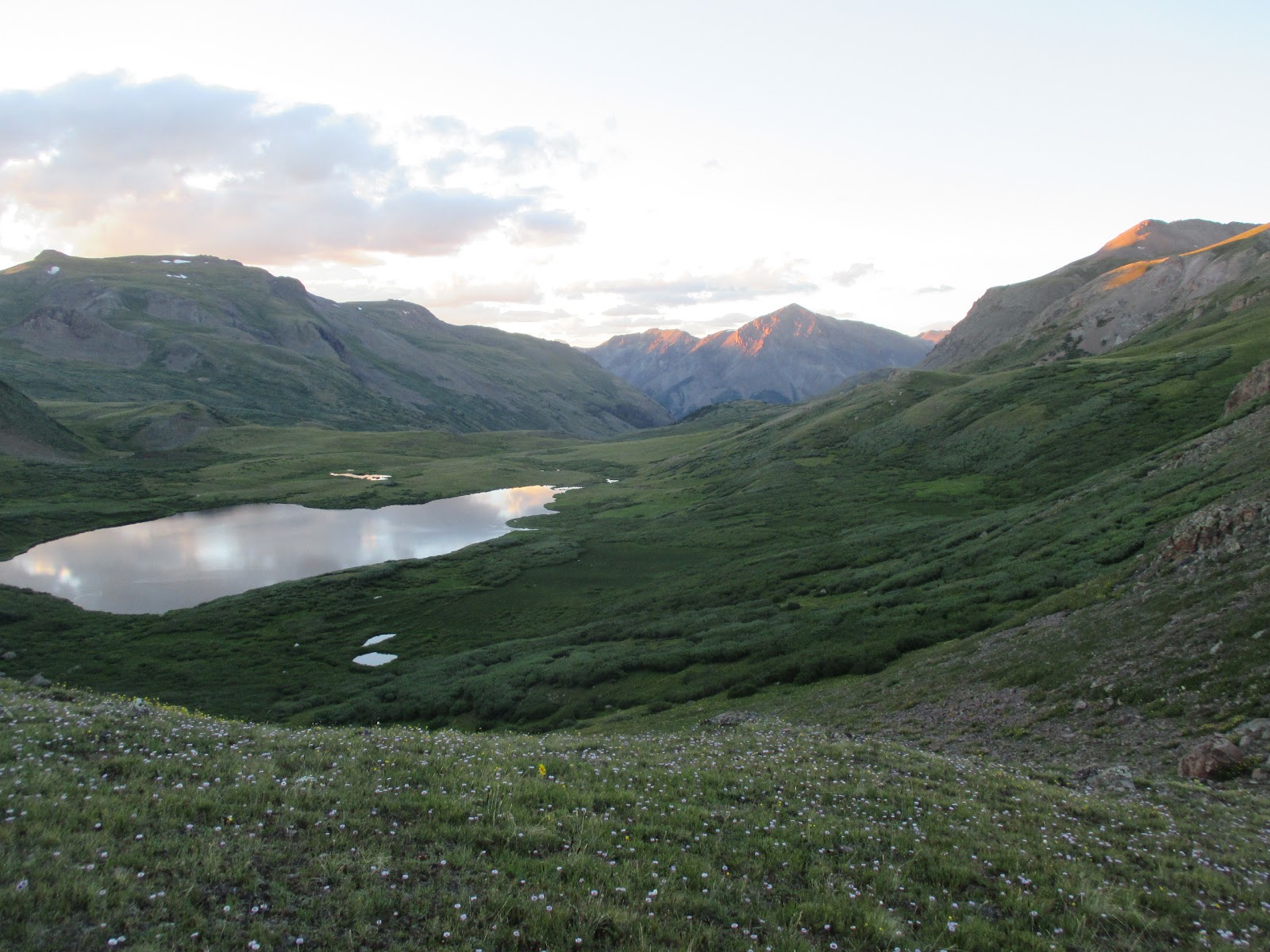
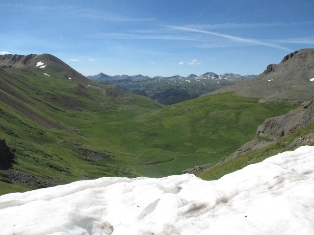
Segment 22 goes higher and stays around 4000m in the tundra. The scenery is spectacular, but very difficult to capture in photos.

The highest point of the Colorado Trail is also in this segment.
By the time I got on to the dirt road, it was afternoon and the weather started to deteriorate, eventually becoming the worst day of my trip as far as the weather was concerned. I was not alone: over the next days, I met a number of people, motorcyclists, through-hikers, other bicyclist, that got caught in this weather at many different places. It was odd to have continuous rain for that long and regional (not just local).
 |
| Deteriorating weather, before La Garita detour |
Despite being on a fairly good dirt road, the solid rain made riding difficult.
 |
| Dirt road for the La Garita detour |
I was not a happy rider that evening:

By about 10 pm (still raining), I pulled into a day use area (there would have been more official campgrounds ahead, but this worked fine for me) and quickly went into my tent to warm up and dry as far as possible. I had done the first big climb of the detour, the next morning would only be another 2 hours or so to get to the top of Slumgullion Pass.
Day 9 - detour to Lake City
The rain stopped in the morning, but the weather remained unstable. I dried things a little bit in the morning sun and then continued.
 |
| Plenty of 4x4 and adventure motorcycles on this stretch. |
Lake City is a cute little mountain town, not much going on, although it milks the fact that this is where Alferd Packer killed and ate his companions while traveling there during the winter in 1874. Aside from the ghosts of his companions, the trackleaders website also showed the ghosts (faded blue) of wanna-be CT racers that didn't make it very far (there are even more of them in Silverton).

Once in town, you can choose between the Cannibal Grill or the Packer Saloon.

Lots of motorcycles, ATVs, and art galleries in the town, an incongruous juxtaposition. Two small grocery stores. I had dinner at the Cannibal Grill and dried out in the Matterhorn motel. It was a very good decision because only that day would have thunderstorms, then the forecast was for 3 days of stable weather.

Day 10: Returning to the route and Segments 22 and 23
The punishment for a comfortable evening in Lake City was the hard 3000 foot road climb back to Slumgullion Pass. Not too much traffic and cars gave me room, but the altitude gain made for a hard morning. Then down on the other side of the Slumgullion Pass and a small climb to Spring Creek Pass, so I already had a hard workout before the day on the trail really started. I arrived at Spring Creek Pass, the start of Segment 22, a bit after 11 am. Not having to worry about lightning storms on those two sections was good and worth the additional day that the Lake City detour added to let the weather settle again.
While those two segments are very attractive, Jarosa Mesa at the beginning of segment 22 is aggravating. Big rocks preventing any riding on a flat top!
 |
| Trail on Jarosa Mesa |
But the trail improves soon and becomes very pretty after the radio tower around mile 7.


 |
| A pretty steep climb, followed by something even steeper |
 |
| The top section of the previous picture |
The highest point of the Colorado Trail is also in this segment.
 |
| Highest point of the Colorado Trail |
The Colorado trail books warn that segment 23 is a hike-a-bike segment, but it really is no more difficult than other parts and much of it is very rideable.

It was around sunset when I got to Cataract Lake and I made camp at the smaller lake next to it.
Day 11: Cataract Lake to Segment 26
The night became quite cold, below freezing, but I was very comfortable in my sleeping bag and slept very well. In fact, after Salida, the altitude no longer bothered me.
 |
| Cataract Lake at Sunset |
Day 11: Cataract Lake to Segment 26
 |
| Cataract Lake area just after sunrise |

Segments 22 and 23 may be the most spectacular of the Colorado Trail. While the tundra is a harsh environment, it also is a very fragile one. Nature's metabolism is slow and despite relatively minor use, evidence of human waste is hard to overlook. In a forest, dig a hole and everything (including toilet paper) disintegrates within days. Up here, well, the hiking season was in full swing apparently and unlike the high Sierra Nevada in California, there appears to be no norm about packing out your toilet paper. I shudder how things look on Mt Everest or similar tourist magnets where visitors have loser standards than on the Colorado trail. In the tundra, it becomes necessary at a minimum to pack out toilet paper. In popular areas, maybe everything, as is the expectation in the Mt Whitney area in California.
Still, those segments were among my favorite parts of the trail. The pictures do not do it justice and these two segments have a unique feel. Some hard hike-a-bike, but overall not less rideable than most of the other trail segments (still, remember, it is the Colorado Trail, so in terms of time, that means as much time walking as in the saddle).
Stony Pass reconnects with civilization, which unfortunately means lots of jeeps and ATVs. Some people feel relieved by that, I find it aggravating and I most enjoy being truly away from all of that. There, the fifth and final mandatory detour begins, which takes me to Silverton. The descent is long, rocky, and steep.In Silverton, I had a burger and fries at a diner and bought two sandwiches at the grocery store for the remainder of the trip, which would only be 1 1/2 days: By tomorrow night, I'd be in Durango. Hwy 550 out of Silverton is the worst unavoidable road riding on the route: no shoulder, heavy traffic, although cars aren't too aggressive. (The Highway 50 detour to Salida is not part of route and only needed to go into town, there are possible dirt road alternatives, and finally, there is a regular bike shuttle to Monarch Pass for the numerous day riders). Segment 25 begins at Molas Pass and was enjoyable riding. Another very pretty section, but totally different from the previous one. Sweet, pretty, rather than harsh, stark.
Still, those segments were among my favorite parts of the trail. The pictures do not do it justice and these two segments have a unique feel. Some hard hike-a-bike, but overall not less rideable than most of the other trail segments (still, remember, it is the Colorado Trail, so in terms of time, that means as much time walking as in the saddle).


Day 12: Last Day and Segments 26, 27, and 28
 |
| Along Indian Ridge |
I had camped relatively early in segment 26, got up around 6 and by 9 am had finished segment 26. At the beginning of segment 27, I met Stacie Mythen and Mark Dunn from Bend who just started their day. Mark was touring the Colorado Trail and had started from Denver a day or two later than me, Stacie was driving a car, going hiking, and met him at a few convenient trailheads. I took a peanut butter and jelly sandwich from them. Stacie was driving to Durango and offered to take my bags (something that is against the rules if you really want to do the route as a race or count as an official time trial), but I was happy to have the last few hours of the ride on a relatively unloaded bike (I still had my tool kit, frame bag, and backpack, but took off tent, sleeping bag, and seatbag). I rode that day with Mark and that was the only time I didn't ride alone, other than the half hour towards Breckenridge with Dan Montgomery on day 2.
This last day was my favorite day of the whole trip and segment 27 with Indian Ridge is just terrific. Best single segment (although all the segments from Molas Pass to Durango are good). The trail was more rideable than average for the Colorado Trail, although it had some hike-a-bike parts. The views were great, but just cannot be captured with a photo.
 |
| I rode with Mark Dunn the last day |

The last part of Indian Ridge involves some hike-a-bike

Around 3 pm, Mark and I reached Kennebec Pass and started our final segment, which includes about 2000 m of descending. The long, bumpy, descent beat me up. That's the first time where I thought a full suspension bike would have been nice!


Around 7.30, I reached the Junction Creek trailhead and my elbows and wrists were glad. Just a little too much single track descending at once. Mark arrived a little earlier (long travel full-suspension bike!). I enjoyed a beer in the parking lot, a bit of conversation, and then rode on to Durango.
A great last day to finish off an outstanding long distance ride!
Overall, I think the last two days had the best parts of the Colorado Trail. Spring Creek Pass to Stony Pass for its spectacular high alpine views (only dud is Jarosa Mesa), Molas Pass to Junction Creek Trailhead for being overall excellent.
No comments:
Post a Comment