About Me

My photo
Santa Monica, California, United States

Sunday, December 25, 2016

Christmas bike ride in the desert

Pinyon Mountain Road and Fish Creek Wash to Split Mountain
A rare rainbow in the desert


For a brief winter break vacation, we made a 2-day trip into Anza-Borrego for some trail running (Kathy and Anya), mountain biking (Roland and Obin), and hiking (all of us). The desert can be very impressive at the right time (in the winter, after some rain). 

Cactus spines glow golden in the low winter sun


Usually the environment is too hostile to leave positive impressions: brutal heat, no shade, no water, deep sand. I have ridden my mountain bike through that area several times as part of a longer tour in March or April and always was glad to get out of the desert. But in December after a storm, it should be different. 


Kathy and Anya dropped us off on County Highway S-2, which also goes by the more vivid name "Great Overland Stage Route". Before it became a great overland stage route (mid 1800s), it was the Mexican mail route. Kathy and Anya went running nearby on the PCT.
Girls went running on the PCT


From the highway, we climbed Pinyon Mountain Road, a sandy road. Conditions were excellent, the sand was well packed and we could ride up without any problems. I remember going the other way a few years ago when the sand was so deep that I had to walk downhill. 
Obin riding up Pinyon Mountain Road (blue jacket is him, red jacket me)

It is about an hour of solid climbing, topping out around 1250 m. We didn't see anybody all day, the only recent tracks were a motorcycle who must have gone through a few hours before us.
near the top, recent moto track on the left

From there, into a labyrinth of rugged canyons, twisted arroyos, and mud hills. The next hour or so is the best riding, mainly downhill with mildly technical parts. 
not a stretch I remembered, but interesting


Mainly downhill, but I only have time to take a picture on the uphills

At one point we ended at a cliff that I couldn't remember, very easy to make a wrong turn here. We didn't try to climb down, though, and after a few minutes of backtracking were on the right route. 
doesn't look like a good way to bike

Fish Creek has always been a deep sand slog for me. This time was mixed. Initially, we had the same old tedious sand, unchanged from other times of year, but it was surprisingly short. Maybe 20 minutes. Then it turned into hard pack. 

Recent rains packed the sand nicely here


Because we started after 12 and the days were short, we didn't have time to explore side canyons.  By the time we got to around the intersection with Sandstone Canyon, the surface has gotten softer again. Every canyon and wash we passed seemed to add water and the surface became softer and softer. 

It didn't take long before the resistance from the soft ground overcame the gravity from the downhill slope and progress was laborious. 


The sun was setting before we reached the Wind Caves, so didn't have time to hike up. And now the surface had unambigously turned into mud. 


Almost, but fortunately not quite, sticky enough to block the tires. Sticky enough to cause chain suck and disabling shifting. It dried up hard by morning, didn't fall apart to loose sand. 


There is a bike chain somewhere under this layer

Now back home and enjoying some of Obin's beer and wine. Love the label of his wine, which reflects how they took home their harvest (on biycles). Obviously limited the amount of wine they could make. 


Friday, November 11, 2016

November Biking in the Sierras


Any day you can pedal through Giant Redwoods is a darn good day, says Erin Carroll 
November 2016 has been a very warm and dry month so far - perfect to go into the high mountains before there is too much snow. Erin Carroll is working on a long-distance bike packing route in the Sierra and wanted to scout a few more trails. Our target area was the Sequoia National Monument/Forest with a little bit in the Inyo National Forest on the last day, the Kern River Sierra.  It is the area south of the Sequoia National Park and Mount Whitney.


Friday: Camp Nelson

We left Friday morning to get some riding in before dark - days are short in November. The riding started in the Giant Sequoia region at Camp Nelson. The ideal plan was a loop of Camp Nelson and Bear Creek Trail, but as we got to the top of Camp Nelson trail, Bear Creek was closed because of a Fire - the Slate Fire, which we would encounter a few more times. So we took the shorter Nelson Trail up and down. It is flowy at the bottom and more technical at the top, a very nice trail, but it takes time (lot of pushing going uphill). 
Camp Nelson trail


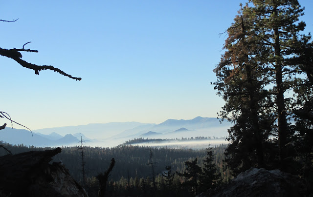
It was well after dark when we finished and quite chilly. Probably better that we could not do  Bear Creek because most of the descent would have been in the dark. We had a primitive campsite higher up in the mountain in mind (Peppermint) and headed there. As we got closer, Erin thought he smelled a camp fire and commented that we were not the only people out that night. Then I smelled it too and it was getting stronger and stronger. Not only that, those campers must be using wet wood as the smoke reflected the headlights. And soon it was so smoky that the road was almost invisible. Ok, so not a campfire, but the smoldering remains of the Slate Fire. We backtracked and tried in the opposite direction and found actually an outstanding site off a dirt road. It was probably around 2200m and the night was cold, but didn't get down to freezing.

My little tent, a superlight Big Agnes that I really like

Saturday: A false start and a long afternoon

Early morning view with smoke-filled valley below

The Slate Fire smoldering in the distance

We had a nice view from our campsite over a valley and Slate mountain. The fire burning in the distance is just where we would have had to climb up on the Bear Creek trail, so that trail was clearly not going to happen this month. 

Instead, we tried the opposite direction and rode our bikes up a road to connect to Summit Trail, but it didn't take long before we hit another fire closure. Slate Fire in the South, now the Jacobson Fire was blocking our way north. As we found out later, both fires were caused by lightning two weeks earlier, but because it was already fairly wet and neither was aggressive, the forest service decided to let them burn out themselves. We tried some smaller trails on the map, but they were overgrown so that it was largely bushwhacking. 

In between the bushwhacking, we came across several large meadows. Surprisingly, they were frozen, even though I was riding in short sleeves and shorts. In the summer, they are probably very swampy and packed with mosquitoes. 
Add caption


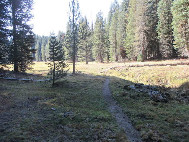
Then more circuitous riding as we got more off course. Even when we finally were on the Summit Trail, it was not in great shape. Most of the scrapes I collected this weekend were from the first 2 hours on Saturday. 

As this area was not promising, we next tried to go south of the Slate Fire. The only option was the Western Divide Highway because all trails and dirt roads west of it were closed.  Erin plans to use those dirt roads for his long-distance route, but we could not check them out because of the fire closures. The Trail of the 100 Giants is along the highway. Feels very touristy with all the paved walkways and big parking lots (and usually $5 parking fee). The trees are impressive, but then so are many of the trees elsewhere - maybe even more so without a concrete path leading to them. 

At Trail of the 100 Giants
 

We went off pavement again at Parker Pass by 2 pm, promptly doing more bushwhacking (but not for long) before we found the dirt road. Long climb and then confusion again: We wanted to take Pup Meadows Trail, found the intersection where it should start, but not the trail. Probably half an hour riding up and down, and then way too far down the mountain and back up. We finally gave up and started to return - then we found it. 
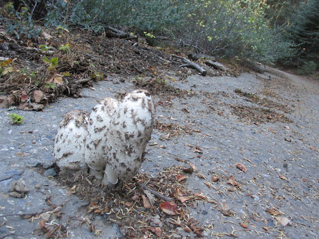
Mushrooms growing out of a crack in the asphalt

Pup Meadows Trail was nice and may end up on the long-distance route. There would be a lovely camp spot at the highpoint. 

It connects with some dirt roads that lead to Frog Meadow Campground where we wanted to go onto the next trail. We had problems finding Tobias trail at the campground because tree cutting messed up the area. Tobias trail parallels Tobias Creek through a steep and rocky canyon. This top part of Tobias is more for downhill riders and I don't think it is that much fun as part of a long ride. We reached the bottom just around sunset, but still had a long way back, which wasn't helped by missing a turn and ending up in Johnsondale, which added another hour of bonus miles - and mostly climbing.

Sunday: Kern Plateau

view into Domeland Wilderness, shortly after Sherman Pass


Sunday started with a car ride: We went to the Eastern Sierra, the Kern Plateau. It is higher than the Western side, but also drier with less vegetation. It would be a long road ride on a bicycle and Sherman Pass might take the better part of a day. That day would have been great, no traffic at all. In the summer, that would be different, though. 

We parked at the Blackrock ranger station and rode up Blackrock road (paved) to connect with the Granite-Broder Trail and later Blackrock Mountain Trail. This area is popular with offroad motorcyclists, so the trails are likely to be sandy during peak season and then probably not good for biking. After a bit of rain recently and no use, they were fairly well packed. 

Eastern part of the Sierra is much drier and sandier

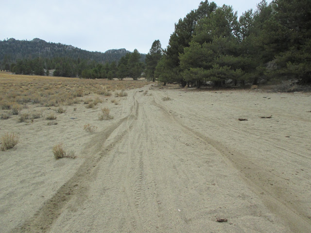
Can't escape the sand in California, even at 2500m

Olancha Peak, we were getting close, a bit over 12000 feet (but not quite 3700m)

Blackrock Mountain Trail turned out to be a hard climb, but a nice trail. It is quite technical and long, so I don't expect it sees too much moto use and may always be in good condition. Our high point that day was around 2700m, maybe we hit 9000 feet. The Monache Mountain 4X4 road was fine for us, but likely to turn into a sand pit in the summer. It was hard climbing as is and with deeper sand would become a walk.

Blackrock Mountain Trail
It took 4 hours to get to what I thought was not much more than the halfway point, so I was very skeptical about continuing, taking into account the experience of the previous day. But Erin was adamant that he wanted to do another trail and claimed that the conditions on this side of the mountains are much easier, trails are more used and maintained. And he was right, we were back at the car in just another 2 hours. The Beach Trail was also my favorite trail on that trip, so no complaints that Erin insisted on more trail riding.


The worst scrapes are always on roads

Looking at my scars, they all seem to be from roads (even one of the collarbone breaks). I took multiple tumbles on the Colorado Trail last year, the only one that hurt and left scars was in a parking lot. On the TransGermany this year, I remember at least two falls, but there probably were more. Nothing happened - until I was in Berlin and the Alexanderplatz left a more durable imprint. Almost always on the right. People are usually weaker making right or left turns, it seems a large majority is weaker on the right (myself included) that even specifically training for it does not change, but those right side falls seem to be more than the common one-side bias should explain.

So this happened on a dirt road once again, coming down from Parker Mesa. It was a reasonably washed out rutted road until a few months ago. Then it was graded and since then has been a wide dusty road. I must have hit one of the few rocks left, but it sure hurt:
Fresh fall, Sept 23
Right around here, middle of the curve (about a 120 degree turn).


Now to the wonders of natural healing. I cleaned it very thoroughly, every day. But initially it didn't look too well and after a week I started to have second thoughts about not going to a doctor to get it stitched up. Now, however, it was to late to do much about it, even when I got some surgical strips. Looked like this would become a particularly ugly scar.


Very nasty looking on Sept 30, a full week later. 

After 2 weeks, the yellow liquid had settled down. But it sure looked like a crater that would scar over.
2 weeks later, October 7


3 weeks later, still not closed, but noticeably less cratered
.
3 weekss, October 14

After 4 weeks, still not closed, but it actually started looking like a minor abrasion.  

4 weeks Oct 21


After 7 weeks, it was all closed, but there are still crusts. Let's see what happens, but it looks like just the usual darker scars, but nothing as ugly as it looked after 2 weeks.
After 7 weeks, November 11 
And 2017!

January 14, 2017


And about 2 1/2 years, December 2 2018. 


Monday, July 25, 2016

Bikepacking Trans Germany

The peloton on a forest trail, photo by Achim Walther

Prologue

TransGermany is a newly developed mountain bike route across Germany that was tackled for the first time in its complete length July 2016. The route starts in the southwestern corner of Germany - or rather just across the border on the Swiss side in Basel - and runs for 1600km/1000 miles to the northeastern corner of Germany on Rügen island in the Baltic sea.  Not an easy ride, but no particularly mean or difficult sections either, and almost completely away from roads with cars. The website is here: https://www.baselona.de/


My progress on trackleaders, it took me 10 days
Achim Walther and Thomas Borst have done the heavy lifting on the route development, with input from others who scouted various sections. The result is impressive, a very diverse route that is largely unpaved forest and agricultural service roads (where no automobile through traffic is allowed), but also plenty of trails, plus some cobblestone, sand, and paved bike paths. 

The route also worked very well on the first try. Most inaugural events have teething problems. I remember a poison oak swamp hike on the first Los Padres, a reservation Sheriff chasing cyclists away on the Stagecoach 400, people getting lost at the end of the TransNorth California. No similar difficulties here even though the route often got to spots where a trail was not initially visible (and without GPS would have impossible to find). But it required a lot of attention to the GPS track. On other routes, I keep my Garmin GPS typically at 1.2 or 2km scale, here I had to use a very fine resolution of 120 or 200m because of many unexpected turns.


Another section that would have been hard to find without GPS.  Picture taken by Achim.
This year offered a good opportunity for a ride outside the US because I had a new research project that involved meetings in Europe and my daughter Anya was going to do a German language course in Austria. Initially, I looked into Mike Hall's Transcontinental, which runs from Belgium to Turkey, and signed up for it. The Transcontinental is largely on roads and I had doubts about finding a good route (in the Transcontinental, you determine your own route except for a few predetermined stretches). The only stretch of the Transcontinental that I already knew was the Furka pass in Switzerland and biking up a big pass in the middle of tour buses is not fun. Then I somehow found a planning thread for the TransGermany route (I don't exactly remember where I heard about it), which sounded much more like my preferred type of riding and made the decision easy to give up my spot in the Transcontinental. I also like the size much better. There were 15 of us at the start of the TransGermany, anybody could join, so a friendly low key event. In contrast, the Transcontinental is huge. Mike Hall said he got 900 applications, 600 of them credible cyclists, and only accepted 1/3 of them. Happy to let one of them have my spot.  

I think another picture by Achim Walther. Achim brought a high quality camera and took 800 photos, so many of the pics in this blog (especially with other riders) are his rather than mine.
The TransGermany route was well planned, but it still was an unknown. Initially, it seemed that since there weren't any major mountains  and a lot of forest roads, 200km a day would be realistic, kind of like Tour Divide. It turns out that mile for mile, TransGermany is harder. The climbs are numerous and often steep, the trails are slow, so except for the slightly faster first and last day, my average speed was around 13 or 14 km/h, making 150-160 already a full day. I think the slow pace of the route surprised everybody. Punchline is that the route is more challenging than it looks on a map. This year, Reto Koller, the first finisher by a long margin, could do it in 6 1/2 days, then people started trickling in after about 8 1/2 days and I was the fourth finisher at 10 1/2 days. The remaining 5 riders all finished at about the same time 2 days later, so 9 finishers out of 14 or 15 starters.    

Day 1, Sunday: Rhein Valley and Schwarzwald


On Saturday afternoon/evening, the day before the start, people trickled in and we met at a shelter hut outside the town and grilled sausages. The gear was identical to any tour in the US: Revelate dominates the saddle bag scene, and Salsa is the most popular bike brand. Just a higher rate  of Rohloff hubs here than in the US.


Official start was at 8 am in Basel, a total of 14 or 15 starters (there was a French guy who showed up just before the start and then was never seen again, not in the picture), and we lined up for the group picture.  


And off we went! Keith Beard, a friend from the Valley of the Moon fiddle camps, happened to be in Basel on business (working in the tall building in the background) and took this picture at the start. 
photo by Keith Beard, who I know from Scottish Fiddlers. 
 The route started to surprise right from the beginning. I expected a paved bike trail at the beginning. That surely also exists, at least on the Germany side. But we almost immediately went on narrow single track along the river, with roots, overhanging tree branches, and multiple hike-a-bike sections (all very short, often to get around ruins from WWII military installations). At km 6, Thomas Borst was the first rider to take a fall and tumble down the steep slope into the river. 
Along the Rhein on the Swiss side
The route starts out flat in the morning, but then there is some climbing into the southern part of the Schwarzwald, which tends to be quite steep. That afternoon I learned the hard way that this route requires particular attention to the GPS. I was still using the 1.2km resolution, missed a turn and descended into the wrong valley. The penalty for that was having to climb back over a ridge, maybe an extra 10km, and also on a busy road to reconnect with the route. Having countless cars and motorcycles pass at high speed on those bonus miles, I also appreciated how much nicer it is to have a route away from cars! Later in the afternoon, I had caught back up with the main group and camped with them in Tuttlingen in the Donau valley. About 150km into the ride. 


Day 2 and 3: Schwäbische Alb

Hohenzollern Burg and Hechingen in the distance, day 2. 


Lots of climbing on the program these 2 days. The route crosses the Schwäbische Alb and despite being a smallish mountain range that barely scratches 1000m, my legs were tired at the end of day 3 and I even had sore quads. 


 On day 2, I rode late into the night, but still barely made 160km, a good indication that this is not a fast route. A nice day, with sprinkles of nice single track, especially near Liechtenstein along the Burgweg. Probably not entirely legal as this is a hiking trail, but as long as no big group of cyclist tries to barrel through, there are no problems. I reached Bad Urach before sunset, bought some food for the night in a supermarket, and went on. Outside the forest, it doesn't get fully dark until about 11 at night, so didn't really need lights until descending in the forest from Hohenneuffen. I camped near Beuren. I think going the other direction (towards Basel), the climb to Hohenneuffen and afterwards out of Bad Urach will be hard. 

Although I found a very nice camping spot, I just couldn't get comfortable and was restless all night. So I started day 3 early, but not rested, which made for a hard morning or really most of the day. 

View from the top, but it'll be down and back up many more times
Achim took the picture below a day after I went through. Steep single track. No, I did not walk, I rode it - at least until my handlebars hit a tree and I tumbled down the hill side. 


Hotel Kronprinz in Ellwangen, recovery evening
Maybe it was lack of sleep, maybe the climbs, or maybe being in the hot afternoon sun on day 3, but I didn't have a good day. My bicycle also started to make noise and I cut the day short and went into a hotel in Ellwangen. Not quite 130 km today, now about 430km on the route.

Some bike repair (mainly  coating all potential squeak sources with vaseline - held up fine for the rest of the ride), shower, nice dinner, comfortable night, and I was ready for fresh start the next day. 


Day 4: Transition along the European Divide

Not a recovery day, but relatively flat and definitely an easier day and I almost made 200km. For a few hours, we seem to track the trail along a divide where water on one side flows to the North Sea and on the other side to the Black Sea. 

 A fine theme, kind of reminiscent of the Great Divide Mountain Bike Route, the original long distance route from Canada to Mexico. Generally the trail worked, although it definitely is less used or maintained. Many turns would have been hard to find without GPS. 
More of the theme "Trust the GPS". But within minutes, there will be a more recognizable trail. 
I didn't say the trail would become more rideable, just more recognizable as one. But such stretches were always very short. 
The scenery was the usual forest roads, but somehow it felt like going up and down all the hills just for exercise and lacked some of the scenic view in the Alb. There are a number of rivers with bike trails in that area that might be alternatives, assuming they flow in the right direction. Eventually, you come out in Erlangen, a larger university town, and the route goes along the Biergarten area on the north side. I had dinner there and then continued for a few hours before I camped.  


Dinner at the Erlangen Biergarten
 Finally a day where the km added up and I started to close the gap to the riders ahead of me a bit, day ended around km 620. By now, we had spread out over quite a distance and the ranking didn't change anymore until the end. Reto Koller was way ahead; maybe 150km later came Olaf Haensch; after Olaf in roughly in 100km gaps Adalbert Nuebling, then me, then the peloton (5 riders that pretty much stayed together until the end), and finally a grupetto of 3 (they did not continue much further). 3 or so had already quit. 

Day 5: Fichtelgebirge

Ggrrh, another restless night. Perfectly nice soft camping spot, I had a shower, everything was clean (I hate being sticky at night), and yet couldn't get comfortable. Bad nights make for less enjoyable days and having a good night matters a lot for a good ride. I would have one more bad night (but that was self-inflicted due to a planning failure), but otherwise the nights were good.  So it would be a shorter day, although that meant I still wouldn't get to the halfway point of the route today. Another literally sore point were my hands. The bike I had bought for the trip had grip shifters and I just didn't get comfortable with them. Otherwise I had set up the bike similar to what I usually ride, including the Jones bar that I brought with me, but those grip shifters almost ruined it. 

I arrived in Bayreuth (best known for its Wagner festivals), the last bigger city for a while around lunch time and left my bike at a bike shop to get a new rear tire and new chain. In terms of mechanicals, no issues. Chain and tire were expected replacements, otherwise I only had annoying squeaks that could be stopped with vaseline. The bike ran fine till the end, then creaks reappeared and now the headset bearings need to be replaced.

The climbing started after Bayreuth, into the Fichtelgebirge. Easier than the Alb. Confusingly, there is also the town of Fichtelberg here, but the highest point of the route, the top of the mountain Fichtelberg, is not here, but in a different mountain range, the Erzgebirge. One unplanned detour due to tree cutting activities, but easy enough to reconnect. 
Trail closed to work, but with all the cut down trees wouldn't be fun to ride here anyway. 


Day 6: Erzgebirge


The Fichtelberg, about km840, is the highest point of the ride and roughly the midway point
Midway point! Highest point of the ride! Aside from those psychologically important milestones, I also got into completely new areas for me, the former East Germany and the Czech Republic. The last time I spent any meaningful amount of time in Europe, Germany was still divided and this area was not accessible. 

My day started at about the corner that joins Bayern, Sachsen, and Czech Republic and crossed into the latter. There would be a few back and forth across the countries today. 


 The route follows the ridge of the Erzgebirge and there is a marked trail for it, the Kammweg. This was one of my favorite stretches of the route. 


The route approaches the Fichtelberg from the Czech side, a fairly hard climb, and I had a recovery beer shortly before the top in Bozi Dar. 

The Fichtelberg itself is a skiing area, so we descend on the ski run before continuing on trails. Then comes a bit of a road stretch through some sad towns on the German side. The former East Germany has lost a lot of its population and many towns feel like they are dying. I had dinner in Jöhstadt, a town with a large market place, big buildings and hotels, yet virtually empty. The big Rathaus hotel closed its kitchen at 7, earlier today because the owner said there were no customers. There was only one restaurant still open in town after 7pm and even there I was the only guest.  
   

Day 7:

Czech scenery of soccer field and hayballs
More back and forth between Germany and Czechia and generally trending downhill. Late in the day, I crossed the Elbe, a river that eventually flows through Hamburg, so no doubt that I was in northern Germany by now. I ended the day at around km 1000. 

Crossing the border is very easy these days. 
 Today I somehow got preoccupied with this Trader Joe's Hazelnut package that I bought in an Aldi. Now, it looks very much like the Trader Joe's logo in California, but we can't find hazelnuts. And why would you find Trader Joe's products in Germany? A logo design coincidence? What has  a hip California supermarket chain in common with a stale German discounter? Long after the ride, the mystery was solved through an internet search: Trader Joe's and Aldi-Nord are owned by the same German parent company. Aldi sells a number of products under the TJ label, but not necessarily products we find in California - like whole hazelnuts. 

 Or lamb filets!

Day 8: Surprise, more climbing

Now I thought we were heading into the flat part of Germany, but not quite. After the Elbe, one more set of mountains, quite low, but also quite steep, the Sächsische Schweiz. I walked my bike uphill here. So the better part of the day and although at that point I had it with climbing, this is a good part. Just needs the mental preparation for it. It isn't a full day either, the route went downhill for good in the afternoon. 

Flat does not mean easy. Along the Polish border, I encountered the first stretch of sand that would make regular reappearances. This day had a lot going for it (not the sand, but the trails earlier in the day), but I messed it up at the end. 

The first problem was that I only brought tinted glasses. Then the sun sets and the bugs come out! Sunglasses don't work well at night and no glasses wasn't working either this evening along the Neisse river. Had to stop countless times for bug extraction, but sunglasses were just too dark. It was late by the time I got to Forst, which otherwise might be a nice town for dinner or even staying for the night, but continued right into the second mistake of the day (or night by then). 

The route had a number of checkpoints, by now we passed 3 of them, and they were all in very pretty settings with good options for the night. And checkpoint 4 was coming up, plus it even showed on the track a shelter at this checkpoint. Seemed like a perfect place. I had used a shelter before the night before, just put my sleeping bag on the table, no need to fiddle around with a tent.

On to Checkpoint 4, almost midnight, almost there. But got smelly, and then what are those noises? Oh, this checkpoint is an open brown coal pit mining operation! 


So on I went for a while, lost my way, but at least deadended in deep sand, which made for a comfortable sleeping place (nice weather, didn't set up the tent, just the sleeping bag in the sand). Near mining drain pipes, which sometimes sounded like a creek, but also had flushing toilet and space alien sounds in their repertoire. 
late night confusion documented on track leaders. My break was so short, it didn't even register as camping

Made for a short and not very good night, but now I was 200km ahead of the peloton. 


The last days: Lakes, Sand, and Mosquitos


The day started a bit rough after a short night and sandy riding, but later in the afternoon was some of my favorite riding on the whole route, the 66-Seen-Wanderweg, small trails going around lake after lake (presumably 66 of those, but we only did a small fraction of those lakes). So progress was slow that day, but certainly enjoyable. I ended the day around km 1340. 


More riding through forests and along lakes the next day. Varying surfaces, there always was some sand and now more often cobblestone. Cobblestone is certainly pretty, but at times it seems more tedious than sand. Surprisingly, even some forest paths between towns were cobblestone here, nothing similar further south. 

cobblestone is pretty, but hard riding

Sand is just tedious. But it isn't as bad as in the desert in California


 Stralsund is the last city (and one of the biggest one along the route) on the mainland, then comes the final 70km finish run on Rügen. 


Insel Rügen


One last ferry ride to get to the top of the island and the last stretch on its northern coast. Actually one of the more disappointing parts, although it looks good on the map. But there is a huge camp ground, so  the last hour seems like riding through a camp ground, plenty of car traffic on dirt roads, and the trails are very crowded. I'd skip that stretch. 

And finished: Kap Arkona, 10 days and 10 1/2 hours after I started in Basel. Adalbert had arrived here the day before and Olaf the day before him. The peloton of the remaining 5 riders on the route were still together about 300 km behind me and would arrive here almost exactly 2 days later. 


I rolled to one of the next towns and enjoyed a relaxing evening in the hotel.  


Epilogue: Berlin detour

Reichstag

The next morning, I rode to Bergen, the closest town on Rügen with real train service. Turns out that it isn't easy to get on a long-distance train with a bike. Yes, there are fast trains going straight to Stuttgart, the next one was in only 1/2 hour and would get there in 8 hours or so. But, no, can't take a bike on it. And really not that many other trains accepted bikes either. The best option was a regional train to Berlin and continuing the next day on a slightly faster train.  By 3 in the afternoon, I was in Berlin starting my sightseeing tour by bike.
Brandenburger Tor

Berlin works surprisingly well for cycling, even in the city center. Having been in Paris the month before, the difference was stark. Paris is congested, noisy, packed with cars; Berlin is more spacious, quieter, and not dominated by cars. I liked it much better. 

I did more than 30km through Berlin on my self-guided tour through Mitte, Charlottenburg, Moabit, Tiergarten, Kreuzberg. As annoying as the train limits for bicycles are, this required layover was great. 

Hard to imagine that as late as 1989 people were killed simply for trying to cross from East to West Germany. 

Checkpoint Charlie, the end of the American sector
The worst scratches are always on pavement! Berlin Alexanderplatz

Remains of the Wall

Time to leave